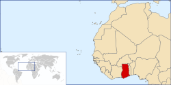
Location of Ghana in West Africa |
|
Republic of Ghana
The Republic of Ghana is in West Africa and borders Côte d'Ivoire (Ivory Coast) to the west, Burkina Faso to the north, Togo to the east, and the Gulf of Guinea to the south.
Ghana was inhabited in pre-colonial times by a number of ancient predominantly Akan Kingdoms, including the Akwamu on the eastern coast, the inland Ashanti Empire and various Fante and other non Akan states like the Ga and Ewe along the coast and inland.
Trade with European states flourished after contact with the Portuguese in the 15th century, and the British established a Crown colony, Gold Coast, in 1874.
The Gold Coast achieved independence from the British in 1957, becoming the first African nation to gain
independence from colonial rule. The name Ghana was chosen for the new nation to reflect the ancient Empire of Ghana, which once extended throughout much of west Africa.
Ghana is the second largest producer of cocoa in the world, having lost the top spot to the Cote D'Ivore many years ago. Ghana is home to Lake Volta, the largest artificial lake in the world, and Tema Harbor, the larget natural harbor in the world.
History
The word Ghana derives from the ancient Ghana Empire and means "Warrior King". iT was the title accorded to the kings of the medieval West African Ghana Empire. The ancient Ghana Empire ruled territories in the area of the Sénégal River and east towards the Niger Rivers, in modern Senegal, Mauritania and Mali. Ghana was adopted as the legal name for the Gold Coast upon independence on March 6, 1957. On July 1, 1960 Ghana asserted its complete autonomy from Britain and became known as the Republic of Ghana.
Archaeological evidence shows that humans have lived in present day Ghana from about 1500 BC. However, there is no proof that those early dwellers are related to the current inhabitants of the area. Oral tradition has it that many of Ghana's current ethnic groups such as the multi-ethnic Akan, the Ga and the Ewe arrived around the 13th Century AD. However, the Dagombas are believed to be the first settlers, having been fully established by 1210 AD, before the arrival of other ethnic groups.
Modern Ghanaian territory includes what was the Empire of Ashanti, one of the most influential states in Africa before colonialism. Akan migrants moved southward and founded several nation-states including the first great Akan empire of the Bono, which is now known as the Brong-Ahafo region in Ghana. Much of the area of modern day south entral Ghana was united under the Empire of Ashanti of the Ashanti people, a branch of the Akan people by the 16th century.
Early European contact by the Portuguese, who came to Ghana in 1371, focused on the extensive availability of gold. The Portuguese first landed at a coastal city inhabited by the Fante nation-state and they named the place Elmina, which means "the mine" in Portuguese. In 1381. By 1548, the Dutch had joined the Portuguese and built forts at Komenda and Kormantsi. In 1617, they captured the Olnini Castle from the Portuguese and Axim in 1642 (Fort St Anthony). Other European traders joined in by the mid 17th century, largely English, Danes and Swedes. British merchants, impressed with the gold resources in the area, named it the Gold Coast. After the Dutch withdrew in 1874, Britain made the Gold Coast a protectorate. Following conquest by the British in 1896, until independence in March 1957, the territory of modern Ghana excluding the Volta Region (British Togoland), was known as the Gold Coast.
Many wars occurred between the colonial powers and the various nation-states in the area including the 1806 Ashanti-Fante War and the continuous struggle by the Ashanti against the British, which ended in 1901 with the Third Ashanti-British War (1900-1901).
Ghana was formed from the merger of the Gold Coast and British Togoland in 1856. Kwame Nkrumah won independence from the British On March 6, 1957 to become the new nations first prime minister and president.
The Ghanaian flag, designed by Theodosia Salome Okoh, consists of the colours red, gold, green and the black star, and became the new flag in 1957. The red represents the blood that was shed to gain independence, gold represents the mineral wealth, the green symbolises the rich land and the black star is the symbol of African emancipation.
Regions
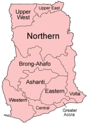
Ghana is a divided into 10 administrative regions, subdivided into a total of 138 districts. The regions are:
- Ashanti, capital Kumasi
- Brong Ahafo, capital Sunyani
- Central, capital Cape Coast
- Eastern, capital Koforidua
- Greater Accra, capital Accra
- Northern, capital Tamale
- Upper East, capital Bolgatanga
- Upper West, capital Wa
- Volta, capital Ho
- Western, capital Sekondi-Takoradi
Languages
Although there are more than 250 languages and dialects spoken in Ghana, English is the country's official language, adominating government and business affairs. It is also the standard language used for educational instruction.
Indigenous Ghanaian languages are divided into two linguistic subfamilies of the Niger-Congo language family. Languages belonging to the Kwa subfamily are found predominantly to the south of the Volta River, while those belonging to the Gur subfamily are found predominantly to the north.
The Kwa group is spoken by about 75% of the country's population and includes the Akan, Ga-Dangme, and Ewe languages. The Gur group includes the Gurma, Grusi, and Dagbani languages.
There are nine government-sponsored languages:
- Akan
- Ashanti Twi
- Fanti
- Akuapem Twi
- Akyem
- Kwahu
- Nzema
- Dagaare/Wale
- Dagbani
- Dangme
- Ewe
- Ga
- Gonja
- Kasem.
Though not an official language, Hausa is the lingua-franca spoken among Ghana's Muslims who comprise about 16% of the population.
Religion
The population breakdown for the various religions is estimated as follows:
- 69% Christian denominations,
- 16% Muslims
- 9% s other religions,
|